


Satellite-ASIGN
وصف لـSatellite-ASIGN
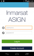
Satellite-ASIGN is an experimental version of UN-ASIGN for crowdsourcing geo-referenced photos, text and disaster needs forms via satellite communications. The intention is to share the data for free with the international humanitarian disaster management community, United Nations, Civil Protection.
Using this App, the communication cost over satellite would not need to be covered by the users of the App. General rights to the photos belong to the users, but Inmarsat is given the rights to share with users and organisations related to this cause. Specifically the observations will be offered to the UN, for integration into live satellite maps.
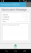
Satellite-ASIGN offers interactive mission-critical visual communications capabilities with geo- and time-tagged photos, where users first send a small preview of a photo, that can be assessed for operational relevance. If and as needed, selected content can later be interactively fetched from the original photos contained within the App.
القمر الصناعي ASIGN هو نسخة تجريبية من الامم المتحدة ASIGN لالتعهيد الجماعي الصور الجغرافية المرجعية والنصوص واحتياجات كارثة الأشكال عبر الاتصالات الساتلية. والقصد من ذلك هو لتبادل البيانات مجانا مع المجتمع الدولي الإنساني وإدارة الكوارث، الأمم المتحدة، الحماية المدنية.
باستخدام هذا التطبيق، فإن تكلفة الاتصالات عبر الأقمار الصناعية لا تحتاج إلى تغطيتها من قبل مستخدمي التطبيق. الحقوق العامة على الصور تنتمي إلى المستخدمين، ولكن يتم إعطاء إنمارسات حقوق مشاركتها مع المستخدمين والمنظمات ذات الصلة لهذه القضية. على وجه التحديد وسيتم تقديم الملاحظات للأمم المتحدة، للاندماج في خرائط الأقمار الصناعية مباشرة.
تقدم الفضائية-ASIGN القدرات التفاعلية الاتصالات المرئية ذات المهام الحرجة مع الصور الجيولوجية والوقت الموسومة، حيث المستخدمين أولا ترسل معاينة صغيرة من صورة، والتي يمكن تقييمها لأهمية التشغيلية. إذا وحسب الحاجة، ويمكن أن يكون المحتوى المحدد في وقت لاحق المنال بشكل تفاعلي من الصور الأصلية الواردة في التطبيق.
Satellite-ASIGN - إصدار 1.2.6
(10-06-2023)Satellite-ASIGN - معلومات APK
نُسخة APK: 1.2.6الحزمة: ansur.asign.inmarsatآخر إصدار من Satellite-ASIGN
نُسخ أخرى


تطبيقات من الفئة نفسها


